|
|
|
Identity of the Municipality Dymi
|
|
Periphery: West Greece
County: Achaia
Municipality: Dymi
Capital: Kato Achaia
|
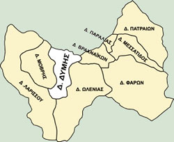
Map of Dymi
|
Click
on the map to enlarge (500Kb - Greek)
|
|
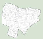
Map of the city center
|
Click
on the map to enlarge (220Kb - Greek)
|
|
|
Sign of Dymi:

Address: 1, Democracy Square, 25200, Kato Achaia
e-mail: info@dymi.gr
|
|
Size: 71553 sq. m.
Population: 10.955 (census of 2001)
Boarders: Eastern with the municipalities of Vrachneika and Olenia, Western with Movri and Larissos and Northern there is the Patraikos Gulf.
Eight (8) Communal Parts: Kato Achaia, Ano Achaia, Alissos, Kato Alissos, Niforeika, Petrochori, Eleochori, Agiovlasitika.
|
|
|
This page was last updated on: July 19 2004.
Web page Creation and Hosting by SilkTech Ο.Ε.
Copyright © 2003 by Municipality of Dymi
|
|